
Cedar Hill ZIP Code Coverage
Cedar Hill is served by the postal designations 75104 and 75106 in official Texas material. The safe way to use either designation is at the address level through USPS, because a ZIP does not define municipal limits or county jurisdiction. Cedar Hill spans Dallas County and a small southern part of Ellis County, so a postal city alone cannot select the right appraisal district, clerk, or GIS map. The coverage table keeps the known facts separate from details that must be confirmed live.
| ZIP | Areas Covered | Post Office | Notes |
|---|---|---|---|
| 75104 | Cedar Hill postal delivery area | Verify through USPS complete-address result | Does not establish city limits or county. |
| 75106 | Cedar Hill postal designation appearing in official Texas and USPS material | Verify through USPS complete-address result | Exact delivery sectors, PO Box allocations, and active address coverage require a current address lookup. |
No official source located a fixed neighborhood-to-ZIP assignment, a complete PO Box allocation, or a verified historic split or realignment year for these Cedar Hill designations. Use US-67, the Joe Pool Lake edge, Old Town, and the southern county line as area descriptions only. Do not turn them into postal boundaries without an official result for the actual address.
Verify Cedar Hill Postal Codes With USPS
The USPS ZIP Lookup has By Address, By City & State, and Cities by ZIP tabs. For the address route, Company, Street Address, City, State, and ZIP fields are available; Street Address is required, while Apt/Suite can refine a multi-unit result. The form has a Find control and result pagination. A city-and-state search can return several ZIP codes, but it cannot show whether a particular Cedar Hill street segment lies within the city, the Ellis County portion, or an adjacent postal area.
| By Address | Use Company if relevant, Street Address, optional Apt/Suite, City, State, and ZIP to obtain a standardized delivery result. |
|---|---|
| By City & State | Use it to see postal possibilities, then return to a full street address for a specific record. |
| Cities by ZIP | Use it to check associated city naming, not to decide a parcel's county or city-limit status. |
| Lookup record | Keep the standardized address, ZIP+4 if supplied, and the date searched. |
A USPS address result verifies postal delivery. It does not establish ownership, occupancy, appraisal jurisdiction, or a person's status in a local record. That distinction is the foundation of a reliable Cedar Hill postal search.
Note: A complete USPS result verifies delivery, while county and city status need separate official records for the same address.
Cedar Hill Postal Address Keys
Three address concepts often appear in the same Cedar Hill research task. A situs or location address is where the parcel sits. A mailing address is where appraisal correspondence is sent. A legal description identifies land by subdivision, lot and block or by metes and bounds. USPS verifies delivery, appraisal cards can show situs and mailing separately, and deeds rely on the legal description. None should be silently substituted for another.
- ZIP code
- A postal routing designation. It is not a city boundary, county boundary, or land-description field.
- ZIP+4
- An added postal routing detail supplied for a particular standardized address when USPS returns one.
- PO Box ZIP
- A designation tied to post-office boxes. It does not automatically describe a street-delivery sector.
- Unique ZIP
- A ZIP used for one institution or organization. No Cedar Hill example was verified in the research.
- Carrier route
- A postal delivery grouping. It is not a legal parcel boundary or a roster of residents.
The difference matters when DCAD lists a mailing address distinct from the parcel situs. The mailing field can provide a lead for correspondence, but it is not proof that the owner lives at the Cedar Hill property.
Cedar Hill Postal Search Fields
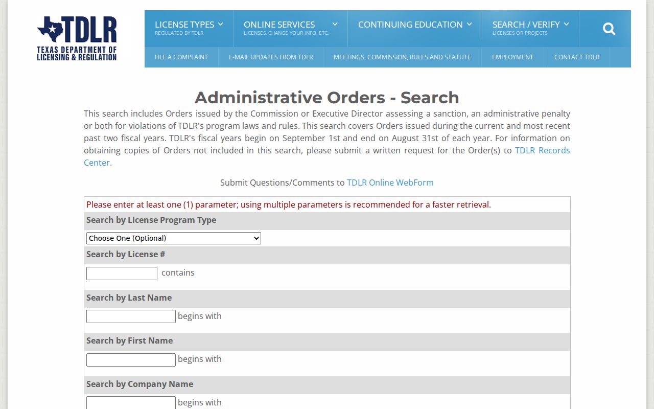
Local portals do not use postal designations in the same way. Dallas Central Appraisal District, or DCAD, exposes a city field in its address search but no visible ZIP field. Its separate owner, account, business, and map routes can still help locate a parcel by street range and map. Texas voter status is name-and-identity based. The Texas Department of Licensing and Regulation, known as TDLR, is the verified portal in this research with a ZIP-equality filter. Its result concerns a regulated license location or mailing information as the board maintains it, not a residence claim.
| Portal field | Field type | Required | Format or use |
|---|---|---|---|
| Program type | Dropdown | No | Choose a regulated program. |
| License number | Text | No | Contains search. |
| Last name | Text | No | Begins-with search. |
| First name | Text | No | Begins-with search. |
| Company | Text | No | Begins-with search. |
| City or county | Dropdown | No | Location filter. |
| ZIP | Text | No | Equality filter; at least one parameter is required overall. |
The TDLR license search is shown below. It is free to search without a login, but a ZIP match should be labeled as the location displayed by the licensing board, not as proof of a person's home address.
A ZIP-wide resident export is not available from every local database. The field differences are a useful reason to verify an address first and then choose the source that actually supports the question.
Note: DCAD's lack of a ZIP input is a portal constraint, not proof that an address lacks postal data.
Find Cedar Hill Residents by ZIP Code
Begin with a real street address or a specific name. A postal designation can narrow the delivery context, but it cannot supply a comprehensive local household list. When a valid ZIP-based result leads to an address, use the parcel's county and the correct appraisal or clerk source to test the record. The sequence below keeps ZIP evidence, property evidence, and license evidence in their proper lanes.
- Enter the complete address in USPS ZIP Lookup and save the standardized result, ZIP+4 if returned, and the lookup date.
- Identify whether the Cedar Hill parcel or event is in Dallas County or the Ellis County portion before opening local records.
- For a Dallas parcel, use DCAD's address, range, or map route because its inspected form has no ZIP field; use ECAD and Ellis GIS for an Ellis parcel.
- Use TDLR's ZIP-equality field only when checking a regulated license location, and keep the board's displayed location type in the notes.
- After a ZIP narrows the area, use the Cedar Hill street directory for the address-keyed parcel and deed workflow.
A voter or license result with a ZIP is not proof that someone owns or occupies a parcel. Conversely, a DCAD account without a ZIP field may still be located by street range and map. The source's field design determines what it can support.
Cedar Hill County Routing
Cedar Hill's two-county footprint is the key geography issue in postal research. Most of the city lies in Dallas County, while a small southern portion reaches Ellis County. A Cedar Hill postal address in either 75104 or 75106 does not answer which county keeps the deed, appraisal account, court file, or local vital record. For Dallas parcels, use DCAD and the Dallas County Clerk. For the Ellis portion, use ECAD, Ellis GIS, and the Ellis County Clerk. Cedar Hill is not a county seat, so Dallas and Waxahachie are the county-record routes.
Dallas County collects Cedar Hill city taxes for both counties, but tax collection does not merge appraisal jurisdictions. This is why the postal label, collector, city limit, and appraisal district must remain separate in a search log. The county question comes before a deed, assessment, or court lookup.
Cedar Hill Map Limits
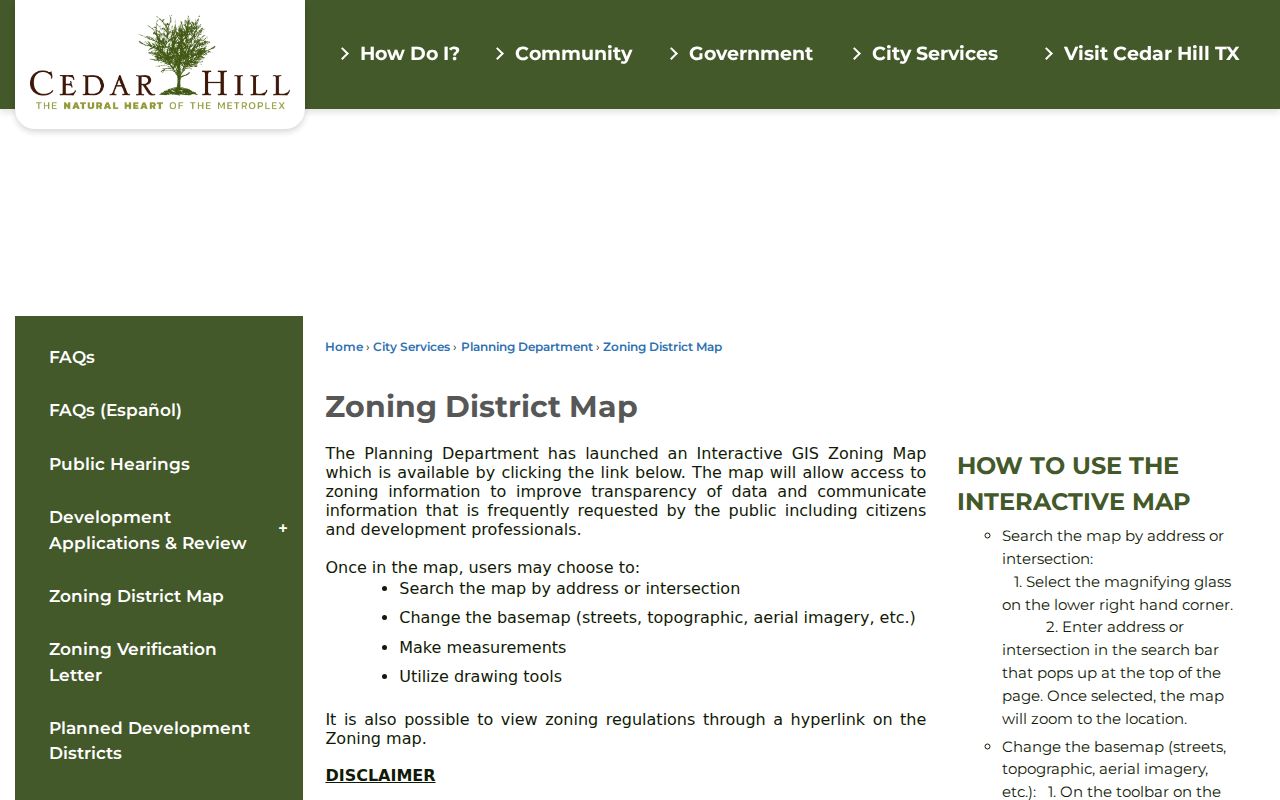
The Cedar Hill zoning map supports address or intersection search, basemap changes, measurement, and sketch tools. It is useful for geographic orientation after USPS has standardized an address. The city warns that the map is for geographic reference only and carries no warranty. It is not a postal-boundary map and cannot prove a ZIP assignment, ownership, or residency.
The zoning map interface appears below. Its disclaimer is especially important near the city edge, where a postal city, municipal line, and county record route can point in different directions.
For the Ellis portion, Ellis GIS provides county web-map access. Open County Maps, choose the Ellis County Web Map, agree to the terms if prompted, then turn on relevant roads, addresses, cities, voting precincts, or public-agency and education layers. Those layers describe geography, not who lives at an address.
Cedar Hill Postal Boundary Mismatches
ZIP boundaries, Cedar Hill city limits, and county lines do not have to match. A USPS city-and-state answer may show a valid postal designation but cannot tell whether a street segment is in the Ellis County portion, inside Cedar Hill limits, or in an adjacent postal area. The same mismatch appears in record systems: DCAD has no visible ZIP search field, TDLR has a ZIP-equality filter, Texas voter status uses identity information, and Ellis GIS exposes geography through layers. Each tool answers a narrower question than “who lives in this ZIP.”
Neighborhood names are not a fix for this mismatch. Cedar Hill's dated neighborhood inventory includes names such as High Pointe, Lake Ridge, Waterford Oaks, Wildflower, Winterhaven, Wooded Creek, and Greenbriar Estates, but it is not a current ZIP boundary map. Assign a named subdivision to a ZIP only after a current official address-level result supports it.
Note: Postal delivery, municipal geography, county custody, and appraisal routing are separate facts, so preserve the source that supports each one.
Cedar Hill Postal History Gap
No official source located a verified year when 75104 and 75106 were split, realigned, or assigned their present coverage. That is a research gap, not a reason to infer a date from an old envelope, a current map, or a business listing. For historic records, retain the printed postal label and date, search the related city, county, deed, directory, newspaper, or census source, and state clearly when the postal history remains unverified.
Note: Report the historic ZIP label exactly as printed and keep the lack of a verified realignment year visible in research notes.
This cautious approach also protects against a common records error: turning one current ZIP result into a claim about an earlier address. The address may have a different postal treatment today even when the county parcel and historic legal description remain the stronger record trail.